
Technologies
‘Weather Whiplash’ Could Be a Disturbing New Normal in a Weird, Warming World
After praying for rain for weeks, the US state that saw some of the year’s biggest wildfires in 2022 found itself soon suffering a deadly deluge.

This story is part of CNET Zero, a series that chronicles the impact of climate change and explores what’s being done about the problem.
I’ve lived in the high desert of the southwestern US most of my life, primarily in New Mexico and Colorado. In those four decades, I’ve never seen it as dry here as in 2022. In all that time, I’ve also never seen it as wet as this year.
In northern New Mexico, the year began with months of unseasonal heat, dryness and extreme wind that fueled the largest wildfire of the year in the lower 48 states. It burned through 340,000 acres of the Sangre de Cristo mountains and destroyed or damaged over a thousand homes and other structures.
Then, in the middle of June, the annual monsoon rains thankfully arrived to douse the fires. But they stayed a couple months longer and dumped nearly twice as much moisture as the previous year (or the year before that). In fact, we were still seeing some monsoon pattern precipitation several weeks later than normal.
There’s a term for this remarkably rapid turnaround in weather patterns that an increasing number of scientists have begun to use, both in the mainstream media and academic publications: weather whiplash.
«The huge shift in weather you experienced in New Mexico this summer is a perfect example,» Jennifer Francis, acting deputy director at the Woodwell Climate Research Center in Massachusetts tells me.
Francis is lead author on a paper published in September in the Journal of Geophysical Research: Atmospheres on measuring weather whiplash events, which can be loosely defined as abrupt swings in weather conditions from one extreme to another.
At my home in the high desert this year, those swings translated into a Spring filled with smoke, heat, wind and the first emergency alert system notice I’d ever received warning me to get off the road immediately due to an approaching dust storm. By July the scene changed to one filled with rain, mud and more alerts, this time warning of flash flooding.
«Weather patterns are getting «stuck» in place more often, causing persistent heatwaves, drought, stormy periods, and even cold spells to happen more often,» Francis explained via email.
Her work shows all this stalled weather is connected to the rapid warming of the Arctic, which impacts the jet stream and in turn affects weather further south.
«These stuck weather patterns sometimes come to an abrupt end by changing abruptly to a very different pattern. This is weather whiplash.»
The phrase has been increasingly used in climate science circles for the past several years, but Francis points to a number of other instances of the phenomenon on full, sobering display in 2022 alone.
A July heatwave immediately followed exceptionally wet, cool weather in the Pacific Northwest and Northern Rockies in June. This turnaround was most dramatic in the Yellowstone region, where historic flooding in the first month of summer took many by surprise and claimed hundreds of homes but, somewhat miraculously, no lives. Shortly afterwards, temperatures soared several degrees above average and the region dried out.
Earlier in the year the inverse played out in Texas, where a spell of 67 consecutive dry, hot winter days in Dallas were followed by the city’s heaviest rains in 100 years, leading to flash flooding and a declaration of disaster by the state’s Governor.
Seasonal See-Saw
From late March until early June, much of northern New Mexico saw no measurable precipitation for a stretch of more than 70 days. Even for the current era, which many scientists suspect is the beginning of a megadrought in the southwestern US, that’s unusually dry.
This dryness, along with unseasonable heat and often extreme winds whipped up the embers of two controlled burns in the Santa Fe National Forest that had been secretly smoldering for months. Two wildfires sprang to life, eventually combining to form the 340,000-acre Calf Canyon-Hermit’s Peak fire complex.
The inferno burned homes, ranches, businesses and livestock, but didn’t claim any human lives – at least, not directly. Tens of thousands were evacuated from nearby cities and villages for weeks as fire devoured some of the state’s most rugged and beautiful terrain over the course of more than two months.
I visited some of the impacted communities to witness the total disruption and devastation while waiting to see if the flames would continue to push closer to my own community near Taos, less than 20 miles from the northwest edge of the fire.
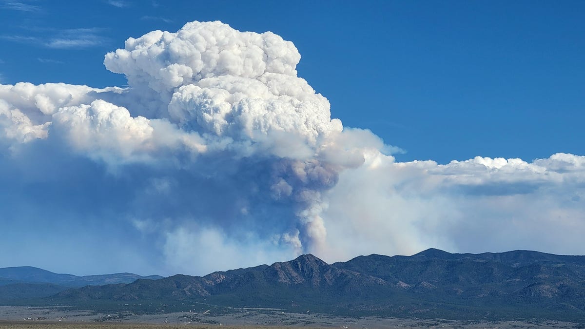
For weeks it looked as though a nuclear bomb had been detonated just over the ridge of mountains near my home. A pyrocumulus mushroom cloud of smoke from the fire reached up into the atmosphere, a constant reminder of impending doom one valley over.
Sometimes the wind would shift and blow all that smoke our direction. It was possible to see this coming almost an hour in advance as a brown stream of smog would suddenly obscure the mountains. As it finally reached us, our eyes would water, our lungs would begin to burn and everything we wore or carried would take on the aroma of a barbecue. Minutes later, the sun would be blotted out on an otherwise sunny day. They were all sunny days back then.
My family would retreat inside every time the smoke came, of course. Then, in early June, another fire ignited on the opposite side of our community from where the megablaze was burning. We found ourselves surrounded. No matter which way the wind blew, there was a good chance it would blow smoke in our faces.
At this point our daughter was quarantined at home with COVID. We faced the very apocalyptic choice of keeping the windows open for better anti-viral ventilation or closing them to keep the smoke out. It wasn’t a particularly hard choice. We closed the windows. Inhaling smoke certainly isn’t great for getting over COVID, after all.
Then, in mid-June, both the weather and its impact took dramatic turns. The annual monsoon rains arrived right on time, and with an unusual intensity. Ironically, this is how New Mexico’s largest ever wildfire ended up claiming human lives after the flames had stopped spreading.
The burn scars left by wildfires absorb less moisture than healthy landscapes with plenty of vegetation, and that led to flash flooding. June and July in northern New Mexico saw repeated cycles of heavy rains, including a particularly heavy storm on July 21 that deluged the Calf Canyon-Hermit’s Peak burn scar. A flash flood tore through the Tecolote Canyon subdivision outside the city of Las Vegas, New Mexico, sweeping tons of mud, rocks, burned trees and even vehicles down the creek drainage. Tragically, three people were caught in the flood and died.
In the span of weeks, citizens in New Mexico went from fleeing fires to fleeing floods. Whiplash might describe the disjointed nature of this past summer, but it doesn’t begin to capture the anxiety brought on by this new realization that life in the 21st century might be about being ready for absolutely anything.
In June I was hauling water to my off-grid home in the back of a truck, 200 gallons at a time, and praying for the monsoon to arrive. The following month I was digging trenches to divert as much water as possible out of my driveway to lessen the persistent rain’s irritating habit of turning it into a muddy quagmire. This is to say nothing of the background anxiety created by nearby fires, floods and at least one epic wind event that took the roof off a neighbor’s house.
The Climate Connection
At least one group of researchers predicted this before it happened. Well, sort of.
On April 1, just five days before that massive fire in New Mexico sprang to life, a paper was published in the journal Science Advances titled «Climate change increases risk of extreme rainfall following wildfire in the western United States.»
The paper describes how scientists used climate models to predict that if global warming continues unabated, the western US will begin to see many more instances of extreme wildfires followed by extreme rainfall. They didn’t wait decades to see their predictions come true. It happened just weeks later.
«I would qualify what happened in New Mexico as extreme precipitation following extreme wildfires,» UCLA and National Center for Atmospheric Research climate scientist Daniel Swain, one of the authors of the study, told me. «Some of those fires were literally still burning pretty vigorously when the rain started. You really can’t get any whiplashier than that.»
Swain is one of a number of climate scientists digging into the data to determine what is creating this new, very 21st century sort of see-saw. One of the main factors, he says, is that the warming of the planet is accelerating the water, or hydrologic, cycle that moves moisture from surface water to the atmosphere and back again via precipitation.
«You actually get an exponential increase in the water-vapor-holding capacity of the atmosphere,» he explains.
Basically, for every degree centigrade of warming, the atmosphere can hold 7% more moisture. These increases compound over time, sort of like interest in a bank account, which provides the exponential acceleration of extreme rainfall events that are more frequent and more intense.
Swain describes our atmosphere as a sponge that grows ever larger as it warms, periodically soaking up potentially larger amounts of moisture and then dumping it all at once on some unfortunate locale. But this expanding sponge is also exacerbating dryness in places where it extracts an increasing amount of water out of the landscape.
This means drier dry periods and wetter precipitation events, sometimes back-to-back. Whiplash.
Swain cautions that it’s too soon to know how much of the weather whiplash experienced in northern New Mexico this year can truly be blamed on climate change versus just basic bad luck and the natural variation and randomness that we’d see in our weather patterns even without global warming.
Climate scientists have developed so-called «weather attribution» models that quantify the effects of climate change directly on specific weather events like what was experienced this year in New Mexico, but the process can take several months or longer.
Weirder than Warming
When I first started covering climate two decades ago, a climatologist told me the phrase «global warming» wouldn’t fully describe what was going to happen to our environment and that it would be more like «global weirding.»
That phrase never caught on, but I’m starting to think weather whiplash might be its appropriate successor.
For decades now, talk about the warming climate has focused on increasing temperatures, but usually these are increasing average temperatures. However, we don’t experience climate in the aggregate. We live it day-to-day as weather that is increasingly extreme.
«If you get 20 inches of rainfall distributed as half an inch a day for 40 days it’s a very different picture than getting 20 inches of rainfall because it rains 10 inches one day and 10 inches the next,» Swain suggests. «The average might be the same, but you’re living in a completely different world.»
In other words, our experience of climate change can’t be fully captured by talking about how much temperatures or sea levels or rainfall are rising. It’s the extremes and the weirdness and the chaotic swings from one state to another that tell the real story and inflict the most trauma.
At the point this summer when wildfires were burning on both sides of our community I had a weird flashback to my childhood. One of my favorite things to read as a kid in the previous century was Choose Your Own Adventure books. They had this intoxicating ability to provide both an escape and agency at the same time.
It feels like we could use a little more of both things right now. Life today has the feel of all the potential adventures in those books happening back-to-back and often simultaneously. The only choice is to be ready for anything.
Technologies
Tinder Users Must Start Logging In With Their Faces, Starting Nationwide
The social app now has new US requirements including face identification to help quell longstanding problems with catfishing and more.

US Tinder users will find a new feature when they open up the dating app starting Wednesday: A mandatory Face Check on their phones will be required before they can log into their profiles.
The Face Check step will begin with a new request to record a video of your face, a more casual version of setting up Apple’s Face ID login. Tinder will then run checks comparing your face data to your current profile pics and automatically create a small face badge for your profile. We already know how it works, because Tinder has already launched the feature in Canada and California before the full US rollout.
The technology, powered by FaceTec, will keep biometric data of the user’s face in encrypted form but discard the scanning video for privacy. Tinder will be able to use the face data to detect duplicate accounts, in an effort to cut down on fake profiles and identity theft.
Don’t miss any of our unbiased tech content and lab-based reviews. Add CNET as a preferred Google source.
Tinder’s facial recognition rollout is also made to prevent catfishing, or people pretending to be someone else on Tinder to scam or blackmail them. But that also points to a deeper problem on the rise in dating apps — a growing number of bots, many controlled by AI, are designed to glean personal information or fool users into scammy subscriptions, among other problems.
Tinder’s working against these bots on several fronts, including this Face Check push as well as ID Check, which requires a government-issued ID and other types of photo verification.
The dating app also recently released a feature in June to enable double-dating with your friends, which Tinder reports is especially popular with Gen Z users. If you’re worried about the latest hazards on Tinder, we have guide to safety practices.
A representative for Tinder did not immediately respond to a request for comment.
Technologies
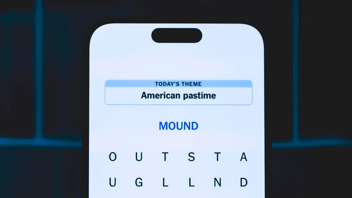
Today’s NYT Mini Crossword Answers for Thursday, Oct. 23
Here are the answers for The New York Times Mini Crossword for Oct. 23.

Looking for the most recent Mini Crossword answer? Click here for today’s Mini Crossword hints, as well as our daily answers and hints for The New York Times Wordle, Strands, Connections and Connections: Sports Edition puzzles.
Need some help with today’s Mini Crossword? Read on. And if you could use some hints and guidance for daily solving, check out our Mini Crossword tips.
If you’re looking for today’s Wordle, Connections, Connections: Sports Edition and Strands answers, you can visit CNET’s NYT puzzle hints page.
Read more: Tips and Tricks for Solving The New York Times Mini Crossword
Let’s get to those Mini Crossword clues and answers.
Mini across clues and answers
1A clue: Like some weather, memories and I.P.A.s
Answer: HAZY
5A clue: Statement that’s self-evidently true
Answer: AXIOM
7A clue: Civic automaker
Answer: HONDA
8A clue: What fear leads to, as Yoda told a young Anakin
Answer: ANGER
9A clue: Foxlike
Answer: SLY
Mini down clues and answers
1D clue: Verbal «lol»
Answer: HAHA
2D clue: Brain signal transmitter
Answer: AXON
3D clue: Hits with a witty comeback
Answer: ZINGS
4D clue: Sing at the top of a mountain, maybe
Answer: YODEL
6D clue: Name of the famous «Queen of Scots»
Answer: MARY
Technologies
Today’s NYT Strands Hints, Answers and Help for Oct. 23 #599
Here are hints and answers for the NYT Strands puzzle for Oct. 23, No. 599.
Looking for the most recent Strands answer? Click here for our daily Strands hints, as well as our daily answers and hints for The New York Times Mini Crossword, Wordle, Connections and Connections: Sports Edition puzzles.
Today’s NYT Strands puzzle might be Halloween-themed, as the answers are all rather dangerous. Some of them are a bit tough to unscramble, so if you need hints and answers, read on.
I go into depth about the rules for Strands in this story.
If you’re looking for today’s Wordle, Connections and Mini Crossword answers, you can visit CNET’s NYT puzzle hints page.
Read more: NYT Connections Turns 1: These Are the 5 Toughest Puzzles So Far
Hint for today’s Strands puzzle
Today’s Strands theme is: Please don’t eat me!
If that doesn’t help you, here’s a clue: Remember Mr. Yuk?
Clue words to unlock in-game hints
Your goal is to find hidden words that fit the puzzle’s theme. If you’re stuck, find any words you can. Every time you find three words of four letters or more, Strands will reveal one of the theme words. These are the words I used to get those hints but any words of four or more letters that you find will work:
- POND, NOON, NODE, BALE, SOCK, LOVE, LOCK, MOCK, LEER, REEL, GLOVE, DAIS, LEAN, LEAD, REEL
Answers for today’s Strands puzzle
These are the answers that tie into the theme. The goal of the puzzle is to find them all, including the spangram, a theme word that reaches from one side of the puzzle to the other. When you have all of them (I originally thought there were always eight but learned that the number can vary), every letter on the board will be used. Here are the nonspangram answers:
- AZALEA, HEMLOCK, FOXGLOVE, OLEANDER, BELLADONNA
Today’s Strands spangram
Today’s Strands spangram is POISONOUS. To find it, look for the P that is the first letter on the far left of the top row, and wind down and across.
-
 Technologies3 года ago
Tech Companies Need to Be Held Accountable for Security, Experts Say
-
 Technologies3 года ago
Best Handheld Game Console in 2023
-
 Technologies3 года ago
Tighten Up Your VR Game With the Best Head Straps for Quest 2
-
 Technologies4 года ago
Verum, Wickr and Threema: next generation secured messengers
-
 Technologies4 года ago
Black Friday 2021: The best deals on TVs, headphones, kitchenware, and more
-
 Technologies4 года ago
Google to require vaccinations as Silicon Valley rethinks return-to-office policies
-
 Technologies4 года ago
Olivia Harlan Dekker for Verum Messenger
-
 Technologies4 года ago
iPhone 13 event: How to watch Apple’s big announcement tomorrow


