Technologies
Take Stunning Landscape Photos With Your Phone Using These Pro Tips
Whether you have an iPhone or Android phone, these pro tips will up your landscape photography game.
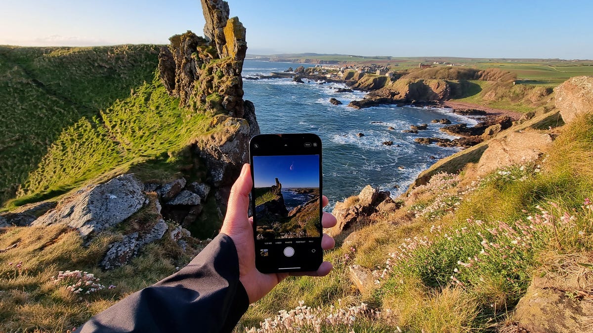
Today’s best phones, such as the iPhone 15 Pro and Samsung Galaxy S24 Ultra, have amazing cameras that can take images that would make even the best cameras jealous. Even older or more affordable phones, like 2021’s iPhone 13 Pro or the new Google Pixel 8, can take beautiful images that you might want to print and display on your wall.
In this guide, I’ll show you how to take landscape photos with your phone, whether you’re heading into the countryside or deep into the heart of the mountains. While some of the tips apply to recent phones with multiple lens options, many are relevant whether your device is three months or three years old, Apple or Android.
Read more: Best Camera Phone to Buy Right Now
Sort your phone camera settings
Your phone is probably capable of taking a cracking landscape photo in its default auto mode, but let’s take things a bit further.
If your phone has a «pro» mode that gives you manual control of settings, switch into that. If it doesn’t, an app like Moment, Lightroom or MuseCam lets you take control of settings like ISO, shutter speed and white balance.
Crucially, these apps also let you shoot in raw format. Raw images don’t save many of the automatic camera settings that your phone would normally apply to a JPEG image, such as white balance or sharpening. The result is an image that lets you change the white balance, alter color tones and rescue detail from the highlights and shadows much more easily — and with less image degradation — than you can with a simple JPEG. I’ll come back to this more in the editing section below.
Apple’s last few generations of Pro iPhone can use the company’s ProRaw format, which uses some computational photography techniques like HDR blending but still generates an easily editable DNG file. Tapping the Raw button on the camera screen will turn on raw shooting. Google has a similar raw function built into its Pixel line.
In landscapes, altering white balance is often crucial as auto white balance might see a scene with a lot of warm tones (such as fall leaves on trees) and try to use a cool white balance to even it out, but in so doing, it loses all of that natural warmth. Being able to tone down some of the highlights from a bright sky or bring up the shadows in the foreground is important, and being able to alter your white balance after you’ve taken the shot gives you much more flexibility in your editing, rather than having the colors baked into the image when you take it.
The downside to shooting in raw is that your images will likely need some work in an editing app like Lightroom or Snapseed before you can share them. Photographing landscapes is often a slower, more methodical process, and spending time in editing is all part of the experience of crafting a beautiful image.
Shoot early, stay out late
Time of day is everything in landscape photography, because the lighting changes completely as the sun passes overhead. The best time of day to catch dramatic light is either at sunrise or at sunset. The sun is low in the sky both times of day, resulting in directional light and long shadows cast over the scene.
Midday is typically the worst time to shoot, as the overhead light doesn’t create much in the way of shadow detail, resulting in scenes that can look flat and lifeless.
If you have a particular location in mind, it’s worth setting your alarm and getting out early to see what you can capture during the sunrise. If time allows, try and return to shoot the same scene at different times of day to see when it looks best.
Watch the weather
Weather plays a huge part in any outdoor photography, but none more so than with landscapes. Different weather conditions will transform your scene, completely altering its mood, lighting and colors. But don’t assume that bad weather means bad photos.
Personally, I love the foreboding, moody atmosphere of a landscape with dark storm clouds billowing above. Often the light that comes after a storm can look particularly dramatic. So while the hike to your chosen location might be a miserable slog in pouring rain, keep your spirits up by imagining the beautiful photo you might get at the end.
The worst weather for landscapes is that plain, miserable gray sky where there’s no texture to the clouds, no interesting light on the land and no contrast to the scene in front of you.
Keep an eye on your favorite weather app and make the decision based on what’s predicted. As long as you’ve packed the right clothing, you can brave the worst of the weather, and if it gets too bad then navigate Google Maps to the nearest pub to sit it out with a good drink.
Experiment with your wide and zoom lenses
If your phone has a wide-angle mode, then now’s the time to give it a try. If you don’t have a wide mode on your phone as standard, you can use additional lenses to get the same effect.
Superwide landscapes can be particularly dramatic, as they capture so much of a scene in a single image. Mountaintops that would otherwise be out of frame are suddenly captured in all their majesty, while beautiful rivers can now be seen in their entirety, snaking their way into a scene.
But once you’ve had the excitement of seeing the scene in full, try using the telephoto zoom lenses on your phone to focus on some of the details within it. Look for interesting rock formations, patterns in the landscapes or unusual shapes in the scene — all of which can stand out when you zoom in or crop out other distracting elements.
Concentrate on composition
It’s easy to think that just using as wide an angle as possible is a guarantee of a cool landscape photo, but that’s not the case. In fact, to get the best out of your wide shots you need to think about composition even more.
Foreground interest
Look for foreground interest in your scenes. Tree stumps, moss-covered rocks, even some pretty wildflowers can all be used to draw the viewer’s eye into a scene. When you’re at the top of the hill taking your shot, spend a couple of minutes having a look around for something you can place in your shot to help bring the scene together.
Leading lines
Leading lines are also great elements of a brilliant landscape composition. Keep your eye out for pathways, nice walls or other long elements that wind their way farther into the scene — it’s exactly that winding perspective that allows your viewer’s eye to follow along a line and into your image.
Straight horizons
If your phone shows grid lines or a leveling tool on the screen, use that to make sure your horizon line is straight. Then double-check you’re not accidentally chopping the top off your subject, be it a mountain, a building or some trees. Remember, you can do a lot to improve a mediocre image with editing, but you can’t do anything to rescue bad composition.
Edit your photos
Your image isn’t finished once you’ve hit that shutter button; a few tweaks in an editing app is all it can take to transform a simple snap into a beautiful piece of art.
My favorite editing app is Adobe Lightroom Mobile, but I also get great results from Google’s Snapseed, which you can get for free on Android and iOS. You can check out my roundup of the best editing apps, which include various options for those of you who like to get a bit wild with your editing.
I tend to start by tweaking the white balance so the colors look accurate, or to give a warmth boost to a beautiful sunset. It’s here that shooting in raw becomes particularly beneficial. I’ll tweak the exposure levels, particularly the highlights and shadows, in order to bring a bright sky a bit more under control or to boost shadows in the foreground. A bit of additional contrast can help add some punch to the scene as well.
My advice is to make a coffee, sit back and play with the sliders in your chosen app to your heart’s content. Try out the different filters and experiment with layering different effects on top of each other by saving and reimporting your image. Remember that there’s no right or wrong way to edit an image, so enjoy playing around — you can always go back to the original image if you don’t like what you’ve come up with.
Technologies
The Fourth Episode of the VERUM AI Mini-Series Is Out
The Fourth Episode of the VERUM AI Mini-Series Is Out

Verum Messenger has released the fourth episode of its AI mini-series SHADOWS, created using Verum AI. The new episode, titled “No Borders,” continues the story of a team trying to stay out of the OMEGA corporation’s sight.
Following the events of the previous episodes, the team moves between cities and countries while OMEGA continues its search. The new episode puts particular emphasis on Verum Messenger’s capabilities that allow users to conceal their location.
“No Borders” is another chapter in a story about privacy, freedom of communication, and technologies that erase borders between people.
The VERUM AI mini-series consists of seven episodes, released gradually across Verum Messenger’s social media channels.
Episode 4 is now available. Stay tuned for the next chapter.
Technologies
Verum Messenger Introduces Built-In Verum Chess
Verum Messenger Introduces Built-In Verum Chess

Verum Messenger has released a new update for iOS, iPadOS, and macOS, adding another feature to its growing ecosystem — Verum Chess. Users can now play chess directly inside the messenger without switching between different applications.
The new feature allows users to start a game in just a few taps while reinforcing Verum’s vision of a unified digital environment where communication and everyday services come together in a single platform.
Verum Messenger continues to evolve into a multifunctional ecosystem that combines secure chats and calls, AI tools, a built-in VPN, anonymous email, eSIM, financial services, cryptocurrency features, and offline communication. With the introduction of Verum Chess, the platform now also offers a new way for users to interact and spend time together without leaving the app.
The update is now available for iPhone, iPad, and Mac on the App Store.
Technologies
Episode 3 of the VERUM AI Mini-Series Is Now Available
Episode 3 of the VERUM AI Mini-Series Is Now Available

Verum Messenger has released the third episode of its AI mini-series, SHADOWS, created using Verum AI.
The new episode, titled «Ghost Money,» continues the story of the conflict between a team of heroes and the Omega corporation, which seeks to take control of digital communications. This time, the focus shifts to anonymous payments and financial freedom, revealing how privacy can extend beyond messaging.
Like the previous episodes, the new release not only advances the storyline but also showcases the capabilities of the Verum ecosystem, highlighting technologies designed for secure communication and digital privacy.
The mini-series consists of seven episodes, released gradually across Verum Messenger’s social media channels.
Episode 3 is now available. Stay tuned for the next chapter.
-
 Technologies4 года ago
Tech Companies Need to Be Held Accountable for Security, Experts Say
-
 Technologies3 года ago
Best Handheld Game Console in 2023
-
 Technologies5 лет ago
Black Friday 2021: The best deals on TVs, headphones, kitchenware, and more
-
 Technologies3 года ago
Tighten Up Your VR Game With the Best Head Straps for Quest 2
-
 Technologies5 лет ago
Google to require vaccinations as Silicon Valley rethinks return-to-office policies
-
 Technologies5 лет ago
Verum, Wickr and Threema: next generation secured messengers
-
 Technologies4 года ago
The number of Сrypto Bank customers increased by 10% in five days
-
 Technologies5 лет ago
Olivia Harlan Dekker for Verum Messenger